




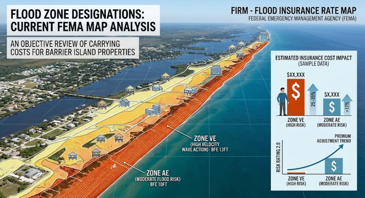
This report provides an objective analysis of FEMA data and its direct quantitative impact on the carrying costs associated with barrier island properties.
Flood zone designations are a primary variable in calculating long-term carrying costs for barrier island real estate. The Federal Emergency Management Agency (FEMA) establishes Flood Insurance Rate Maps (FIRMs) to delineate risk levels. A thorough understanding of these designations and the resulting insurance premium calculations under current national frameworks is essential for accurate financial modeling.
This analysis evaluates current FEMA flood zone classifications, recent methodological changes in premium calculations, and the direct quantitative impact of these factors on holding costs for coastal properties.
Analyzing FEMA Flood Zone Classifications
On barrier islands, properties predominantly fall into one of two Special Flood Hazard Areas (SFHAs): Zone AE or Zone VE. Both zones require flood insurance if the property is secured by a federally backed mortgage.
- Zone AE: These areas are subject to inundation by the 1-percent-annual-chance flood event (historically referred to as the 100-year flood). Properties in this zone are typically located further inland on a barrier island or along intracoastal waterways where wave action is minimal.
- Zone VE: These are coastal high-hazard areas subject to the same 1-percent-annual-chance flood event but with the added risk of storm-induced velocity wave action (waves exceeding 3 feet). Properties situated directly on the oceanfront or highly exposed coastal edges generally carry this designation.
Properties located in Zone X are outside the SFHA (the 0.2-percent-annual-chance flood area). While flood insurance is not federally mandated for Zone X, statistical models indicate that a significant percentage of flood claims still originate from these areas.
The Quantitative Impact of Risk Rating 2.0
Historically, National Flood Insurance Program (NFIP) premiums were calculated primarily using a property’s base flood elevation (BFE) and its specific flood zone. However, FEMA’s implementation of Risk Rating 2.0 fundamentally altered this actuarial model.
Risk Rating 2.0 utilizes a broader set of variables to determine a property’s specific flood risk and associated premium. The calculation now incorporates:
- Distance to water: Proximity to oceans, rivers, and bays.
- Topography and Elevation: The specific ground elevation of the structure relative to the water source.
- Cost to Rebuild: The replacement cost value (RCV) of the home.
- Flood Frequency and Type: Analysis of river overflow, storm surge, coastal erosion, and heavy rainfall data.
Impact on Carrying Costs: Risk Rating 2.0 assesses risk on an individualized basis rather than applying a uniform zone-wide rate. As a result, properties within the same flood zone, such as two homes in Zone AE, may have significantly different insurance premiums.
From a quantitative standpoint, barrier island properties face the highest average premiums due to storm surge vulnerability. Data indicates that coastal properties transitioning into the Risk Rating 2.0 system have seen gradual premium adjustments. By law, existing NFIP premiums cannot increase by more than 18% annually until they reach their full risk rate.
When calculating holding costs, it is necessary to account for these compounding annual increases. For instance, a property with a subsidized legacy premium of $1,500 transitioning to a full risk rate of $4,000 will experience an 18% statutory increase each year, which directly reduces net operating income (NOI) during the transition period.
Base Flood Elevation (BFE) and Construction Standards
The most significant controllable variable in mitigating these carrying costs is the property's relationship to the Base Flood Elevation (BFE). The BFE is the computed elevation to which floodwater is anticipated to rise during the base flood.
- Positive Elevation (Above BFE): Structures built with their lowest floor above the BFE demonstrate significantly lower actuarial risk. Quantitative models show that even 1 to 2 feet of freeboard (elevation above the BFE) can result in substantial premium reductions, lowering the annual carrying cost of the asset.
- Negative Elevation (Below BFE): Older, non-conforming structures built before modern FIRMs were established often sit below the current BFE. These properties represent the highest insurance carrying costs under current actuarial models.
Furthermore, construction standards in Zone VE require specialized engineering, such as open foundations (pilings or columns) and breakaway walls, to allow wave action to pass beneath the structure. Non-compliance with these strict structural requirements directly disqualifies a property from favorable premium tiers.
Summary Data for Acquisition Analysis
During the underwriting process for barrier island acquisitions, it is essential to integrate the following research data into financial models:
- Map Verification: Verify the current FIRM status, as map revisions occur periodically and can change a property's SFHA designation overnight.
- Elevation Certification: Secure an up-to-date Elevation Certificate to determine the precise relationship between the lowest floor and the BFE.
- Full Risk Rate Analysis: Request the full Risk Rating 2.0 premium estimate, not just the current owner's subsidized rate, to accurately project future carrying costs.
Incorporating precise flood risk data and statutory insurance calculations into the acquisition process is essential for maintaining a quantitatively robust barrier island portfolio.
Check out this article next